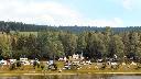
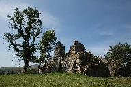
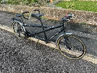
Tandem Club GPX/TCX Rides list

As a club we have many organised rides including national and international large events as well as local regional group rides. Quite a few of these have been made available to members using route sheets and more recently GPX/TCX files for sat navs. This is a database of all of these rides allowing you to view and download GPX/TCX files and route sheets where available.

We are slowly adding all of our rides to this database. If any member is willing to help that would be great ! These rides are provided on an as is basis if you ride them you do so entirely at your own risk. The Club, its officers and ride organisers accept no responsibility for loss, damage to property, accident, injury or death, that may occur, however caused, whether by negligence, deliberate act or otherwise. Any RO/member can add rides to make it easy for members to access them.

You can add rides using the Add Ride link. You must have a website login account to do this.By default the Selection criteria will be for rides in your own group. Set this to "All" to list all rides and click on the "Search" button. Some assistance with using this system is at: Help. You can just view and add places of interest using PlaceList. Note that when you have added a ride you can view it with a background map and proceed to add places of interest. This system is still a work in progress. Please feedback issues/ideas to: webgroup@tandem-club.org.uk.

Select the rides (Help)
GroupMap Ref (lat,long)Quality
Modified PeriodPostcodeShow on a map
Search textShow placesShow GPX tracks
Page1 of 3 OrderPersonal
Show profile
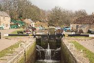
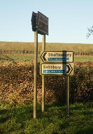
Id: 489, Quality: 5
Group: Touring
Location: Bradford on Avon
Postcode: BA15 1LE
Map Reference: 51.3416, -2.25175
Ride length: 17 km
Ride ease: Average
Added by: Neil Wheadon
You start by the Kennet and Avon on the edge of the town to climb briefly towards Westwood. Westwood is a pretty village and contains Westwood Manor which is managed by the National Trust and opens in the summer. Onto a narrow lane which descends steeply towards an A Road, but take the descent slowl ...
Id: 486, Quality: 5
Group: Touring
Location: Yatton Keynell
Postcode: SN14 7BA
Map Reference: 51.4866, -2.19355
Ride length: 7 km
Ride ease: Easy
Added by: Neil Wheadon
Starting in Yatton Keynell, this section of the Wiltshire Cycleway is the shortest and probably the flattest as it heads through the arable landscape of the southern Cotswolds. It passes through Biddestone which is quintessentially English Cotswold with a central duck pond surrounded by lovely Cotsw ...
Id: 485, Quality: 5
Group: Touring
Location: Corsham
Postcode: SN13 9HT
Map Reference: 51.4305, -2.18424
Ride length: 15 km
Ride ease: Average
Added by: Neil Wheadon
This section of the Wiltshire Cycleway starts to the east of Corsham by the war memorial. Heading south you descend and climb, don't forget to look at the deep cutting of the railway line below. Entering open countryside you cycle small lanes as you head towards Atworth. On the outskirts you'll zig ...
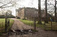
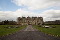
Id: 484, Quality: 5
Group: Touring
Location: BA12 7JF
Postcode: Maiden Bradley
Map Reference: 51.1501, -2.28574
Ride length: 16 km
Ride ease: Easy
Added by: Neil Wheadon
Starting at Maiden Bradley you head through open countryside towards the village of Kilmington that is strung out along the lanes. This section is gradually downhill and you glide towards Stourton which is famous for it's fabulous gardens managed by the National Trust. The Wiltshire Cycleway bypasse ...
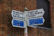
Id: 474, Quality: 5
Group: Touring
Location: Great Bedwyn
Postcode: SN8 3NU
Map Reference: 51.3794, -1.60182
Ride length: 21 km
Ride ease: Average
Added by: Neil Wheadon
This section of the Wiltshire Cycleway starts in the centre by the phone box (now an information centre). Head slightly uphill towards the Three Tuns pub where there is a good signpost punting to Little Bedwyn and you will pass the edge of this viewing the attractive church. Into open countryside th ...
Id: 471, Quality: 5
Group: Touring
Location: Dilton Marsh
Postcode: BA13 3GW
Map Reference: 51.2487, -2.20667
Ride length: 17 km
Ride ease: Average
Added by: Neil Wheadon
This is the 2nd section of the Wilshire Cycleway, which has been written to provide great detail on this circular route. The other 15 sections are on RidewithGPS, but for an overview please visit bikexplore.co.uk/Articles-of-Interest/Wiltshire-Cycleway Starting at the eastern end of Dilton Marsh, ve ...
Id: 463, Quality: 5
Group: Touring
Location: Broad Chalke
Postcode: SP5 5EN
Map Reference: 51.0295, -1.9454
Ride length: 15 km
Ride ease: Average
Added by: Neil Wheadon
Starting from the Queen' Head in Broad Chalke the route heads east along a moderately busy road passing through Stoke Farthing and Bishopstone. As you cycle, don't miss the cycle orientated wind machines on the left as you pass through these extended villages. IMPORTANT As a writer I am not sure how ...
Id: 460, Quality: 5
Group: Touring
Location: Donhead St Mary
Postcode: SP7 9DQ
Map Reference: 51.0189, -2.13455
Ride length: 15 km
Ride ease: Average
Added by: Neil Wheadon
Starting by the church at Donhead St Mary, descend quite steeply to head left and then climb to follow the lane east towards Berwick St John. Care as you cross the A30 before cycling a delightful flattish lane to pass through Berwick and onto Alveston. You will pass througha glorious holloway lined ...
Id: 459, Quality: 5
Group: Touring
Location: The Walnut Tree Pub
Postcode: BA12 6BH
Map Reference: 51.0851, -2.26267
Ride length: 18 km
Ride ease: Average
Added by: Neil Wheadon
This is the 4th section of the Wilshire Cycleway, which has been written to provide great detail on this circular route. The other 15 sections are on RidewithGPS, but for an overview please visit bikexplore.co.uk/Articles-of-Interest/Wiltshire-Cycleway You can start this ride from Mere, which is rec ...
Id: 414, Quality: 5
Group: Touring
Location: Garsdale Head
Postcode: LA10 5PW
Map Reference: 54.3231, -2.32982
Ride length: 15 km
Ride ease: Easy
Added by: Neil Wheadon
This sections starts at the road leading from Garsdale Head railway station. Head downhill to the A684 to head down to the valley. The Cumbrian Cycleway used the A Road all the way, but it is worth taking the old road, signed Grisedale close to the start as it's quieter but also affords lovely views ...
Id: 413, Quality: 5
Group: Touring
Location: Kirkby Stephen
Postcode: CA17 4QN
Map Reference: 54.4734, -2.34884
Ride length: 19 km
Ride ease: Average
Added by: Neil Wheadon
Starting from the information centre at Kirkby Stephen you head south along Market Street passing shops, cafes and an outdoor shop, because this is also on the coast to coast walking route. Heading left close to the end of town you are heading towards Nateby with lovely views of the Pennines on the ...
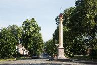
Id: 412, Quality: 5
Group: Touring
Location: Appleby in Westmoreland
Postcode: CA16 6XB
Map Reference: 54.5801, -2.49049
Ride length: 17 km
Ride ease: Average
Added by: Neil Wheadon
The ride starts from railway to the north of the centre of Appleby-in-Westmorland. You descend towards the town to bear right into the centre. It's an attractive place with many older buildings worth a look. You cycle up Boroughgate, a wide main street. It is marked by two pillars at the top and the ...
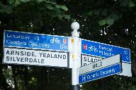
Id: 411, Quality: 5
Group: Touring
Location: Kirkby Lonsdale
Postcode: LA6 2AH
Map Reference: 54.202, -2.597
Ride length: 23 km
Ride ease: Average
Added by: Neil Wheadon
There are a few big roads around Kirkby Stephen but this route has a cunning way out. Heading out from the centre you cross the A65 by a dedicated cyclepath. It's not particularly easy as there is a lot of traffic on this road, but the infrastructure remains. There follows quite a climb through narr ...
Id: 410, Quality: 5
Group: Touring
Location: Langwathby
Postcode: CA10 1LH
Map Reference: 54.6949, -2.66507
Ride length: 25 km
Ride ease: Average
Added by: Neil Wheadon
You start with a short but steep climb out of Langwathby past the station on your right. Your reward is a delightful quiet lane that climbs gradually towards the Pennines to Kirkland via Skirwith with lovely views all around. The route then turns southerly for a descent past Blencarn Lake and into t ...
Id: 409, Quality: 5
Group: Touring
Location: Newbiggin
Postcode: BA3 5LS
Map Reference: 54.8351, -2.69056
Ride length: 20 km
Ride ease: Hard
Added by: Neil Wheadon
The scenery on this section continues as it did before with views of the Lakeland Fells on the right whilst being in the shadow of the Peninnes on the left. It's just all pretty, with some long descents and a number of climbs. If you have time, Long Meg Stone Circle is worth a visit. Long Meg is the ...
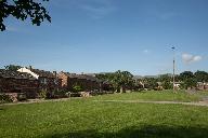
Id: 408, Quality: 5
Group: Touring
Location: Carlisle
Postcode: CA3 8XL
Map Reference: 54.9015, -2.94525
Ride length: 32 km
Ride ease: Average
Added by: Neil Wheadon
The start at Eden Bridge isn't particularly easy to find especially as it's a pretty short indistinct bridge. The best way to find it is either head for the Athletics stadium or better still; it's at the western edge of Bitts Park close to the Castle However the exit out of Carlisle works an absolut ...
Id: 407, Quality: 5
Group: Touring
Location: Bowness-on-Solway
Postcode: CA7 5AF
Map Reference: 54.953, -3.21489
Ride length: 21 km
Ride ease: Easy
Added by: Neil Wheadon
It's a flat run to Carlisle and hopefully a Westerley wind will push you along. Very close to the start it is worth looking for the small sign to the Hadrian's Wall Walk on a house wall. This leads to a shelter with good views over the Solway and is the start of the walk, you will see folks walking ...
Id: 406, Quality: 5
Group: Touring
Location: Silloth
Postcode: CA7 4AD
Map Reference: 54.8686, -3.3892
Ride length: 37 km
Ride ease: Easy
Added by: Neil Wheadon
From the centre of Silloth head down to the shore to head along the wide promenade shared with pedestrians. There is plenty of room so take your time to enjoy the sea views and the groins keeping the beach in place. At the end continue along the road to the village of Skinburness where you leave the ...
Id: 405, Quality: 5
Group: Touring
Location: Maryport
Postcode: CA15 6AB
Map Reference: 54.7146, -3.50181
Ride length: 20 km
Ride ease: Easy
Added by: Neil Wheadon
Starting at Maryport bridge the route heads to the coast passing the church on the left. There are a few things to see in Maryport from an aquarium quayside to 2 museums including Roman artefacts. The promenade runs along the Solway Firth it's wide enough to be shared with pedestrians from where you ...
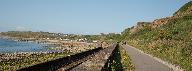
Id: 404, Quality: 5
Group: Touring
Location: Whitehaven
Postcode: CA28 7LY
Map Reference: 54.5481, -3.59276
Ride length: 25 km
Ride ease: Hard
Added by: Neil Wheadon
There has been a lot of renewal in Whitehaven since the Cumbria Cycleway was put together and the very start shows of the new promenade as you cycle with marina on the left and cafes on the right. Rope knot sculptures add to the charm. You stay with the sea as an old railway hugs the coastline givin ...
Id: 397, Quality: 5
Group: Touring
Location: Ravenglass
Postcode: CA18 1SW
Map Reference: 54.3564, -3.41006
Ride length: 32 km
Added by: Neil Wheadon
You exit Ravenglass via narrow walkway strapped to the side of the railway bridge. This drops to a short length of rough track close to the shore that affords good views back to the village after which you hit tarmac to head inland crossing the railway to join the A595. Heading left and through Drig ...
Id: 394, Quality: 5
Group: Touring
Location: Millom
Postcode: LA18 5AA
Map Reference: 54.2112, -3.27122
Ride length: 32 km
Ride ease: Average
Added by: Neil Wheadon
From Millom the route heads south through Ventner so if you had stayed at the harbour lights campsite, you're close to the route. On the coast it has a tiny harbour and a shop. You head out towards the Western Fells and will be under the shadow of these for most of this section. It's an agricultural ...
Id: 393, Quality: 5
Group: Touring
Location: Ireleth
Postcode: LA16 7DL
Map Reference: 54.1887, -3.20382
Ride length: 25 km
Ride ease: Average
Added by: Neil Wheadon
Starting from the railway station you head along the A595 with a stiff climb. The reward is a fantastic descent with views into the valley with a backdrop of Lakeland fells to the left as you descend. There is a gate pull in that gives a better view close to the top of the descent. The road is moder ...
Id: 392, Quality: 5
Group: Touring
Location: Ulverston
Postcode: LA12 7BA
Map Reference: 54.1959, -3.09637
Ride length: 35 km
Ride ease: Average
Added by: Neil Wheadon
Staring in Ulverston by the war memorial, you descend the cobbled streets to a large roundabout where you exit the town. The road is flat to gentle incline and passes a Buddhist centre LHS, you can see the golden temple through the trees. After a few miles you reach the coast probably marked by exte ...
Id: 391, Quality: 5
Group: Touring
Location: LA11 6EH
Postcode: Grange Railway Station
Map Reference: 54.1963, -2.90301
Ride length: 24 km
Added by: Neil Wheadon
From Grange station you head into the centre of Grange, heading left at the roundabout to pass cafes on the right. An uphill short climb to a roundabout by a clock. There follows a monster climb out of town (route 700 goes left). After this the road undulates with some downhill to the pretty village ...
Id: 390, Quality: 5
Group: Touring
Location: Arnside
Postcode: LA5 0HA
Map Reference: 54.2022, -2.83476
Ride length: 26 km
Ride ease: Easy
Added by: Neil Wheadon
This section starts at Arnside Pier. It sounds grand but it's smaller than expected being a 20 metre stone structure that juts into the estuary. From the pier the ride sweeps the bay heading briefly inland before extensive views to the left of Morecambe Bay and the fells. Swinging north and inland, ...
Id: 389, Quality: 5
Group: Touring
Location: Sedbergh
Postcode: LA10 5BZ
Map Reference: 54.3236, -2.52825
Ride length: 23 km
Ride ease: Average
Added by: Neil Wheadon
Starting from Sedbergh the route heads west and out of the town along the A684, from where it turns left along the A683. Although these are A Roads the traffic is reasonably light and you are travelling initially downhill including the initial A684. The ride heads down the Middleton Valley and is a ...
Id: 355, Quality: 5
Group: Touring
Location: Tavistock
Postcode: PL9 0DF
Map Reference: 50.5515, -4.14673
Ride length: 35 km
Ride ease: Easy
Added by: Neil Wheadon
There were 2 railways from Tavistock and the viaduct that dominates the north part of town has now been opened as a cyclepath giving lovely views over the town hall and centre. Unfortunately much of the railway path has been lost so to get out of the town the route twists and turns towards Plymouth ...
Id: 354, Quality: 5
Group: Touring
Location: Okehanpton
Postcode: EX20 1AP
Map Reference: 50.7397, -4.00105
Ride length: 32 km
Ride ease: Average
Added by: Neil Wheadon
Dartmoor tors loom above you and it is towards these that you climb from the centre of Okehampton. Pass behind the church not missing the mural/statue on the left before climbing Station Road to Okehampton Station, which has just been reconnected with a passenger service to Exeter. The route now run ...
Id: 353, Quality: 5
Group: Touring
Location: Petrockstowe
Postcode: EX20 3HR
Map Reference: 50.8757, -4.10992
Ride length: 30 km
Ride ease: Average
Added by: Neil Wheadon
Id: 352, Quality: 5
Group: Touring
Location: Barnstaple
Postcode: EX31 2BN
Map Reference: 51.0793, -4.07028
Ride length: 35 km
Ride ease: Easy
Added by: Neil Wheadon
The track on the other side is much smoother; where the other side was full of raised tarmac due to tree roots this side is as smooth as glass. Fremington quay is extremely popular. The site of former industry there is a playpark, large picnic area and a bustling cafe with about 20 picnic tables. If ...
Id: 351, Quality: 5
Group: Touring
Location: Ilfracombe
Postcode: EX34 9EQ
Map Reference: 51.2109, -4.11179
Ride length: 25 km
Ride ease: Average
Added by: Neil Wheadon
Part 1 of the Devon Coast to Coast The start is at Ilfracombe and what better place to start than the enormous statue designed by Damian Hurst. Not only is it striking but it's also easy to see as she points to the sky. The first part is convoluted, as the folks designing these routes will do anythi ...
Id: 340, Quality: 5
Group: Touring
Location: Lands End YHA
Postcode: TR19 7NT
Map Reference: 50.1159, -5.68774
Ride length: 46 km
Ride ease: Average
Added by: Neil Wheadon
The hardest climb of the day is at the start as you climb through Bosavern to St Just. Joining the A3071 takes you into the pretty centre of St Just which contains everything you'll need from cafe's, hotels and a well stocked shop, Be careful as you exit as it's 1 in 6 with a left hand bend at the b ...
Id: 337, Quality: 5
Group: Touring
Location: Penzance
Postcode: TR18 2NF
Map Reference: 50.1219, -5.53304
Ride length: 29 km
Ride ease: Average
Added by: Neil Wheadon
Starting at the train station in Penzance, the route heads uphill and out of town to view Ding Dong mine. There are some off road sections here. Heading south you'll pass the ancient village of Carn Euny where you can walk amongst the foundations of ancient homesteads The ride finishes at Lands End ...
Id: 336, Quality: 5
Group: Touring
Location: Coverack YHA
Postcode: TR12 6SA
Map Reference: 50.0211, -5.09901
Ride length: 54 km
Ride ease: Average
Added by: Neil Wheadon
Exitting the YHA at Coverack, the route is pretty flat as you ride through common land actively managed by Exmoor Ponies on both left and right. Onto a moderately busy B road to turn left and gradually descend a road with lovely views passing the satalitte dishes of Goonhilly on the right. Turn righ ...
Id: 334, Quality: 5
Group: Touring
Location: Devoran Quay
Postcode: TR3 6ND
Map Reference: 50.2061, -5.06983
Ride length: 38 km
Ride ease: Average
Added by: Neil Wheadon
Head out of Devoran Quay, heading through Devoran. The entrance to the cyclepathis marked by a granite marker on the bend in the road. The track is firm, so folow this under a bridge to take a wooden bridge on the right to bear right and climb a byway where the surface is fine for narrower tyres. De ...
Id: 313, Quality: 5
Group: Touring
Location: Bitton
Postcode: BS30 6HD
Map Reference: 51.4305, -2.47599
Ride length: 14 km
Ride ease: Average
Added by: Neil Wheadon
From the railway station at Bitton, carry on down the railway path towards Bath. By the Millennium signpost leave the path to enter Saltford, leaving this and into the countryside to the west of Bath. Through the lanes with views of Bristol to the right to arrive at Compton Martin. Climb again, then ...
Id: 312, Quality: 5
Group: Touring
Location: Iron Acton
Postcode: BS37 9UG
Map Reference: 51.5506, -2.46768
Ride length: 16 km
Ride ease: Easy
Added by: Neil Wheadon
This part is almost a straight line due south and it starts with a lovely gated lane free of traffic through the fields. Welcome to Frampton Cotterell reads the sign as the route passes through this settlement to the north of Bristol passing shops and a welcome tearoom. Out the south side, under a v ...
Id: 311, Quality: 5
Group: Touring
Location: Wickwar
Postcode: GL12 8NE
Map Reference: 51.5963, -2.4009
Ride length: 20 km
Ride ease: Average
Added by: Neil Wheadon
Descend from Wickwar for extensive views. For so close to Bristol, it's a surprise to find a large common, but Hawkesbury Common provides an unfenced road scattered with small holdings and good views. The Somerset Monument looms ahead on the hill, but don't worry, although you can go that way the cy ...
Id: 309, Quality: 5
Group: Touring
Location: Clapton-in-Gordano
Postcode: BS20 7RH
Map Reference: 51.4615, -2.75991
Ride length: 17 km
Ride ease: Easy
Added by: Neil Wheadon
Bristol is a big city, but this section cleverly takes you through the northerly part using quiet roads and cycletracks. From Clapton-in-Gordano a series of lanes takes you towards the Avonmouth Bridge almost in a straight line using a couple of quieter lanes with views of the docks to the left. Thr ...
Id: 308, Quality: 5
Group: Touring
Location: Brockley
Postcode: BS48 3AT
Map Reference: 51.3976, -2.75968
Ride length: 16 km
Ride ease: Easy
Added by: Neil Wheadon
You're into rural North Somerset now as you pass through farming country that has shades of the Somerset Levels to the south. In it's own way this is one of the prettier sections of the cycleway. The Grade 1 listed Chelvey church dates from the 12th century and you pass this on your right as you rid ...
Id: 307, Quality: 5
Group: Touring
Location: Chew Stoke
Postcode: BS40 8XE
Map Reference: 51.3525, -2.63359
Ride length: 12 km
Ride ease: Average
Added by: Neil Wheadon
You climb out of Chew Stoke, zig-zagging through the outskirts of this pretty Somerset village. Keep climbing until you reach a chimney in a field to the right, long since disused. The lanes flatten now as you pass to the south of Winford, heading towards Bristol airport, along whose northern border ...
Id: 306, Quality: 5
Group: Touring
Location: Pensford
Postcode: BS39 4AQ
Map Reference: 51.3714, -2.54839
Ride length: 9 km
Ride ease: Easy
Added by: Neil Wheadon
Pensford is an arbitory start, because you have to start somewhere. The route heads along a quiet lane that passes under the now disused railway viaduct that last saw a passenger train in 1968. The lane is quiet and leads to Upper Stanton Drew where it is well worth taking the diversion to look at t ...
Id: 303, Quality: 5
Group: Touring
Location: Littleton-upon-Severn
Postcode: BS35 1NR
Map Reference: 51.6078, -2.58495
Ride length: 18 km
Ride ease: Average
Added by: Neil Wheadon
Heading west, there will be more climbing than the previous section, but nothing strenuous as you gradually rise and fall with some lovely views across the Severn Valley. Round the outskirts of Thornbury with a grand church on the corner before the major climb of this section to cross the A38 (take ...
Id: 302, Quality: 5
Group: Touring
Location: Hallem
Postcode: bS10 7RZ
Map Reference: 51.5173, -2.64901
Ride length: 16 km
Ride ease: Easy
Added by: Neil Wheadon
One of the flatter sections you'll cycle takes you along the Severn Vale. Being close to Bristol and quiet, it's popular with local cyclists. For much of the section you'll get a look at both the new (on the left) and the old (on the right) Severn Bridges leading to the foothills of Wales. Olvaston ...
Id: 301, Quality: 5
Group: Touring
Location: Bradford-on-Avon
Postcode: BA15 1LE
Map Reference: 51.3416, -2.25175
Ride length: 17 km
Ride ease: Easy
Added by: Neil Wheadon
Bradford on Avon is your starting point for the Wiltshire cycleway and the first few kilometres have much to offer. From a 14th century Tithe Barn, to a Manor House or maybe a castle in an unexpected location. Exiting Bradford on Avon, a short climb takes you through Westwood before a quiet lane and ...
Id: 256, Quality: 5
Group: Touring
Location: Portreath
Postcode: TR16 4LX
Map Reference: 50.2621, -5.29085
Ride length: 19 km
Ride ease: Easy
Added by: Neil Wheadon
The Coast to Coast Trail closely follows the line of two historic transport routes. The early horse-worked Portreath tramroad opened in 1812. This was the first surface tramroad in Cornwall. It gave the copper mines around Scorrier and St Day a transport route to the sea at Portreath. Portreath has ...
Id: 482, Quality: 4
Group: Touring
Location: Pewsey Railway Station
Postcode: SN9 5FB
Map Reference: 51.3421, -1.77074
Ride length: 46 km
Ride ease: Average
Added by: Neil Wheadon
Follow the Avon River from the Vale of the White Horse via Stonehenge and Old Sarum Castle to Salisbury Cathedral. Combine with the Wylye Valley & Salisbury Plain Explorers for a spectacular three-day circular navigation of South Wiltshire Terrain : Mostly quiet lanes with minor urban roads and brid ...
Id: 480, Quality: 4
Group: Touring
Location: Warminster Station
Postcode: BA12 9BP
Map Reference: 51.2067, -2.17689
Ride length: 50 km
Ride ease: Average
Added by: Neil Wheadon
Cycle the range from Westbury White Horse to the Pewsey Vale. From tanks to wild orchids, explore this unique cycle route around the Imber and Larkhill military ranges. Combine with Avon & Wylye Valley Explorers for a spectacular three-day circular navigation of South Wiltshire Terrain : Minor urban ...
Id: 479, Quality: 4
Group: Touring
Location: Salisbury
Postcode: SP2 7RS
Map Reference: 51.0703, -1.80503
Ride length: 37 km
Ride ease: Easy
Added by: Neil Wheadon
This is part of a 3 day loop ride through Wiltshire put together by Wiltshire County Council From the Cathedral City of Salisbury past the majesty of Wilton House, take the back road through the Wylye Valley past some of Wiltshire's finest chalk downland to the market town of Warminster. Combine wit ...