
Account
Pictures
Tandem Club GPX/TCX Rides list
 |
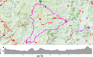
Id: 754, Quality: 4 Group: SouthEastWales Location: Pontypridd Postcode: CF,NP Map Reference: 51.6048, -3.3416 Ride length: 50 km Ride ease: Average Added by: Stephen Adams | The ride starts from the Good's Yard car park in Pontypridd and goes north on the Taff Trail to Quakers Yard. From there it follows the Trevithick Trail (The Trevithick Trail - NCN Route 477 | visitmerthyr.co.uk) to Merthyr Tydfil. In Merthyr there are many cafes and there's the chance to visit Cyfa ... |
 |
Id: 729, Quality: 4 Group: SouthEastWales Location: CF,NP Postcode: CF,NP Map Reference: 51.4623, -3.45272 Ride length: 39 km Ride ease: Average Added by: Stephen Adams | This ride starts from The Butts car park in Cowbridge and proceeds south to Llantwit Major via the village of Flemingston. Return is to the West and then to Colwinston, Llysworney and Llanblethian. |
 |
Id: 1147, Quality: 3 Group: SouthEastWales Location: Pontypool Postcode: NP4 6LG Map Reference: 51.6991, -3.0367 Ride length: 53 km Ride ease: Hard Added by: Neil Wheadon | Start from Pontypool Park Car Park,Pontypool NP4 6LG |
 |
Id: 1034, Quality: 2 Group: SouthEastWales Location: Llethrau, Felindre, Knighton Postcode: LD7 1YT Map Reference: 52.4437, -3.26024 Ride length: 85 km Ride ease: Hard Added by: Neil Wheadon | |
 |
Id: 1033, Quality: 2 Group: SouthEastWales Location: Farm, Llethrau, Felindre, Knighton LD7 1YT Postcode: LD7 1YT Map Reference: 52.4438, -3.26321 Ride length: 60 km Ride ease: Hard Added by: Neil Wheadon | Heading east, we leave the centre to climb. Above you to the right you might see Castell Bryn Amlwg, a motte of an old castle. Descending we come to Clun, where there is a cafe and a castle that shouldn't be missed. A section of A raod with a climb and descent takes us to Bishop's Castle whch is a c ... |
 |
Id: 664, Quality: 2 Group: SouthEastWales Location: CF,NP Postcode: CF,NP Map Reference: 51.5794, -2.83126 Ride length: 36 km Ride ease: Easy Added by: Stephen Adams | The ride starts at the Magor Square car park and goes to the cafe at the RSPB wetlands centre |
 |
Id: 662, Quality: 2 Group: SouthEastWales Map Reference: 51.6054, -3.3405 Ride length: 41 km Ride ease: Average Added by: Stephen Adams | |
 |
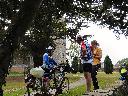
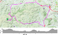
Id: 661, Quality: 2 Group: SouthEastWales Location: CF,NP Postcode: CF,NP Map Reference: 51.6054, -3.3405 Ride length: 43 km Ride ease: Average Added by: Stephen Adams | Three tandem crews from the SE Wales group rode this on the 19th July 2023. The Colliers Rest at 9.2 miles is a good stop - the only downside is that there's a flight of steps to get tandems up to it. The steps are just the other side of the stone bridge over the railway (if you're doing the route c ... |