
Account
Pictures
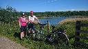
John and Janice
Forsale
Tandem Club GPX/TCX Rides list
 |
Id: 1854, Quality: 3 Group: NationalCycleNetwork Location: Sumburgh Head Car Park, Shetland Postcode: ZE3 9JN Map Reference: 59.8579, -1.27201 Ride length: 176 km Ride ease: Average Added by: Neil Wheadon | See https://www.walkwheelcycletrust.org.uk/find-other-routes/shetland-islands-sumburgh-to-lerwick-and-norwick/ See https://en.eurovelo.com/ev12 North Sea This is a 136.7-mile route connecting Sumburgh to Lerwick and Norwick throughout Scotland's Shetland Islands. Throughout the Shetland Islands, the ... |
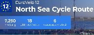 |
Id: 1853, Quality: 3 Group: NationalCycleNetwork Location: Sumburgh Head Car Park, Shetland Postcode: ZE3 9JN Map Reference: 59.8577, -1.27217 Ride length: 164 km Ride ease: Average Added by: Neil Wheadon | See https://www.walkwheelcycletrust.org.uk/find-other-routes/shetland-islands-sumburgh-to-lerwick-and-norwick/ See https://en.eurovelo.com/ev12 North Sea Cycleroute Path number 1 / EV12 This is a 136.7-mile route connecting Sumburgh to Lerwick and Norwick throughout Scotland's Shetland Islands. Thr ... |
 |
Id: 834, Quality: 3 Group: NationalCycleNetwork Location: Okehampton Postcode: EX20 1AP Map Reference: 50.7397, -4.00101 Ride length: 48 km Added by: Neil Wheadon | https://www.sustrans.org.uk/find-a-route-on-the-national-cycle-network/route-28/ |
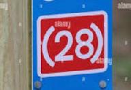 |
Id: 833, Quality: 3 Group: NationalCycleNetwork Location: Newton Abbot Postcode: TQ12 4AD Map Reference: 50.533, -3.59657 Ride length: 47 km Added by: Neil Wheadon | https://www.sustrans.org.uk/find-a-route-on-the-national-cycle-network/route-28/ https://www.hartstongue.co.uk/index.php/transport/2699-national-cycle-route-ncn28 |
 |
Id: 831, Quality: 3 Group: NationalCycleNetwork Location: Ilfracombe Postcode: EX34 9FF Map Reference: 51.2091, -4.11357 Ride length: 64 km Added by: Neil Wheadon | It's very difficult to find any information on this route https://www.exmoor-nationalpark.gov.uk/enjoying/expeditions-and-groups The route includes coastal views across Combe Martin Bay then reached Lynton, with its harbour. From Lynton, the route continues along the East Lyn River and around Porloc ... |
 |
Id: 830, Quality: 3 Group: NationalCycleNetwork Location: Turnpike Cross Map Reference: 51.1749, -4.16954 Ride length: 12 km Added by: Neil Wheadon | https://www.sustrans.org.uk/find-a-route-on-the-national-cycle-network/route-278/ |
 |
Id: 829, Quality: 3 Group: NationalCycleNetwork Location: Georgeham Map Reference: 51.1404, -4.18423 Ride length: 12 km Added by: Neil Wheadon | https://www.sustrans.org.uk/find-a-route-on-the-national-cycle-network/route-278/ |
 |
Id: 828, Quality: 3 Group: NationalCycleNetwork Location: Ilfracombe Postcode: EX34 9EQ Map Reference: 51.2108, -4.11185 Ride length: 7 km Added by: Neil Wheadon | https://www.sustrans.org.uk/find-a-route-on-the-national-cycle-network/route-27/ |
 |
Id: 827, Quality: 3 Group: NationalCycleNetwork Location: Turnpike Cross Postcode: EX34 7HQ Map Reference: 51.1749, -4.16953 Ride length: 7 km Added by: Neil Wheadon | https://www.sustrans.org.uk/find-a-route-on-the-national-cycle-network/route-27 |
 |
Id: 826, Quality: 3 Group: NationalCycleNetwork Location: Turnpike Cross Postcode: EX34 7HQ Map Reference: 51.1749, -4.16954 Ride length: 5 km Added by: Neil Wheadon | https://www.sustrans.org.uk/find-a-route-on-the-national-cycle-network/route-27 |
 |
Id: 825, Quality: 3 Group: NationalCycleNetwork Location: Georgeham Map Reference: 51.1404, -4.18423 Ride length: 5 km Added by: Neil Wheadon | https://www.sustrans.org.uk/find-a-route-on-the-national-cycle-network/route-27 |
 |
Id: 824, Quality: 3 Group: NationalCycleNetwork Location: Georgeham Postcode: EX33 1JW Map Reference: 51.1404, -4.1842 Ride length: 15 km Added by: Neil Wheadon | https://www.sustrans.org.uk/find-a-route-on-the-national-cycle-network/route-27 https://www.sustrans.org.uk/find-a-route-on-the-national-cycle-network/tarka-trail |
 |
Id: 823, Quality: 3 Group: NationalCycleNetwork Location: Barnstaple Postcode: EX32 9AH Map Reference: 51.0685, -4.05517 Ride length: 15 km Added by: Neil Wheadon | https://www.sustrans.org.uk/find-a-route-on-the-national-cycle-network/route-27 https://www.sustrans.org.uk/find-a-route-on-the-national-cycle-network/tarka-trail |
 |
Id: 822, Quality: 3 Group: NationalCycleNetwork Location: Barnstaple Postcode: EX32 9AH Map Reference: 51.0685, -4.05522 Ride length: 37 km Added by: Neil Wheadon | https://www.sustrans.org.uk/find-a-route-on-the-national-cycle-network/route-27 https://www.sustrans.org.uk/find-a-route-on-the-national-cycle-network/tarka-trail |
 |
Id: 821, Quality: 3 Group: NationalCycleNetwork Location: Petrockstowe Map Reference: 50.8754, -4.10987 Ride length: 37 km Added by: Neil Wheadon | https://www.sustrans.org.uk/find-a-route-on-the-national-cycle-network/route-27 https://www.sustrans.org.uk/find-a-route-on-the-national-cycle-network/tarka-trail |
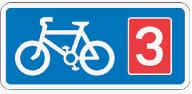 |
Id: 820, Quality: 3 Group: NationalCycleNetwork Location: Sheepwash Postcode: EX21 5NE Map Reference: 50.8364, -4.15102 Ride length: 7 km Added by: Neil Wheadon | https://www.sustrans.org.uk/find-a-route-on-the-national-cycle-network/route-3 |
 |
Id: 819, Quality: 3 Group: NationalCycleNetwork Location: Petrockstowe Postcode: EX20 3QG Map Reference: 50.8754, -4.10987 Ride length: 7 km Added by: Neil Wheadon | https://www.sustrans.org.uk/find-a-route-on-the-national-cycle-network/route-3 |
 |
Id: 818, Quality: 3 Group: NationalCycleNetwork Location: Meeth Postcode: EX20 3QB Map Reference: 50.8517, -4.066 Ride length: 5 km Added by: Neil Wheadon | https://www.sustrans.org.uk/find-a-route-on-the-national-cycle-network/route-3 https://www.sustrans.org.uk/find-a-route-on-the-national-cycle-network/tarka-trail |
 |
Id: 817, Quality: 3 Group: NationalCycleNetwork Location: Petrockstowe Postcode: EX20 3QG Map Reference: 50.8754, -4.10985 Ride length: 5 km Added by: Neil Wheadon | https://www.sustrans.org.uk/find-a-route-on-the-national-cycle-network/route-3 https://www.sustrans.org.uk/find-a-route-on-the-national-cycle-network/tarka-trail |
 |
Id: 815, Quality: 3 Group: NationalCycleNetwork Location: Holemoor Postcode: EX22 7AH Map Reference: 50.8316, -4.23345 Ride length: 7 km Added by: Neil Wheadon | https://www.sustrans.org.uk/find-a-route-on-the-national-cycle-network/route-3 |