Account
Discussions
Satnav GPS question
Hi all
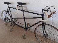
New poster here, after some general advice about satnav and GPS systems. I am planning a tour on the tandem with my teenage daughter in Central Asia and will be pretty much off grid for most of it. I am old school, and have grown up with maps and a compass, and can navigate absolutely fine with that. However, that does not satisfy my family, who would like the ability to communicate with us.
Does anyone have any experience with Garmin/Wahoo/etc, and would be able to share their experience of using them not just to navigate but to communicate with the folks back home? Whenever I search online, I just find loads of articles explaining how to upload my latest training data from my garmin to my social media accounts so that I can boast about how far I have gone, how quick I was, etc, etc. I don't want to do that, I just want to let my family know that I'm OK! I know I can buy a satellite phone, but that is a lot of money for the phone then there is the monthly contract, all of which soon adds up.
If anyone has any info, I'd be very grateful.
Ben
Most Garmin and Wahoo units won't be much help, because they communicate via a mobile phone! I take it that by off grid, you mean no mobile phone signal. I've got no experience of the Garmin Inreach unit recommended by Bob Cohn, but it sounds as if it might be what you need.
As others imply above, it depends on what you mean by "off-grid" in your comment above. If you don't plan on having a phone with you at all then that will limit your options, but if you are planning on taking a phone then it will enable messaging and tracking options on devices like wahoo and Garmin etc. These devices will work without the phone as they have inbuilt gps but generally rely Ona phone connection at some stage to upload data and messages etc. e.g. at the end of the day when you pick up phone signal ina town or similar? They also have the advantage of allowing you to plan and follow routes in areas where you may not have paper maps as you can download digital maps in advance in areas where you have phone coverage.
As an example, We plan routes on our Wahoo ( using Komoot typically), we can then follow these routes just using the wahoo device on the handlebar. We then upload the route at the end of the day via mobile phone link which allows our family and friends to check what we have done and that we have arrived somewhere. Planning and changing routes though is best done in areas with mobile phone coverage.
if you are truly Off grid the satellite spot checkers may be your best bet.
I download vector maps, hill shades, countour lines, and wikis into my phone, and partner's too if we're travelling together, using OSMAnd+. I don't subscribe as I bought in to the + version in the early days of the app, but I highly recommend this app. You can have fully fledged off-line maps with off-line navigation. It uses OpenStreetMap data which is very good in many countries, but cross check at openstreetmap.org beforehand. I always have this in my pocket, an a battery pack or two with me, so between us we have redundancy for charge and/or breakages.
MapsMe for a much simpler experience, OruxMaps for a paid-for cartographer-nerd mode, Komoot for a popular paid-for planning and mapping app. I'm okay with just OSMAnd+, but we're all different.
I've often created routes in AllTrails or the like on a PC, pre-loaded them into an old Garmin 200, so I just have a breadcrumb trails to follow, with back up detailed offline mapping in a pocket.
If you are spending some time in areas where on-grid is possible, if your phone supports eSIM, I recommend Airalo or purchasing data-only in off-contract territories, for staying in touch without relying solely on finding WiFi. eSIMs usually about $7 for 1 Gb for a week,
Thank you all for the info, it has been very helpful. Just to clarify what is meant by off-grid, we are looking at a trip to Kyrgyzstan. Mobile (cellular) signal might be available in cities and larger towns but for the other 94% of the country you are reliant on satellite communication!
The paper maps of the country are hard to come by, lack detail and are based on the old Soviet maps made during the 1980's! Nakarte.me is a good mapping site which shows different maps like OSM, Google, CyclOSM, etc, as well as different satellite images. These are handy for route planning, and you can then download them and print them out, so you can have a paper back up.
Have you tried messaging Ed Pratt via his YouTube site! As well as unicycling around the world, Ed did a tandem tour in Kyrgyzstan, as well as living there for a while. Throughout that time he travelled, filmed and blogged etc, so he would know what is and isn't possible there.
I don't know him, but his world tour and Kyrgyzstan tour YouTube is a good watch and worth asking him a question perhaps?


